Customer
UK Foreign and Commonwealth Office (FCO)
Mission Location
Pitcairn Islands Marine Reserve
Highlights
- Successfully detected surface vessels (even “dark” targets) operating in the surveillance area
- Captured high-definition images of vessel targets and sent thumbnails to command center
- Provided the FCO significant cost savings compared to operating a manned vessel
“Advances in the sophistication and affordability of technology give us the opportunity to monitor and understand marine life within protected areas as never before.”
The Challenge
The Foreign and Commonwealth Office (FCO) had a massive challenge: How to protect 840,000 square kilometers of remote marine habitat without incurring the expense and risk of manned missions. Working in conjunction with The Pew Charitable Trusts and the Satellite Applications Catapult’s new monitoring platform, “Project Eyes on the Seas,” the FCO enlisted the help of Liquid Robotics and its Wave Glider platform to cost-effectively patrol the waters around the Pitcairn Islands.
For this mission, Eyes on the Seas fisheries analysts remotely directed the Wave Glider using both satellite surveillance and their knowledge of the fishery. Combining self-propulsion with advanced sensors and sea-to-satellite communications, Wave Gliders can detect and track vessels to help governments safeguard their most valuable marine resources.
The Approach
The FCO enlisted the help of Liquid Robotics to close the gap in maritime surveillance without the expense or risks associated with manned missions.
The Wave Glider platform is the only unmanned system capable of powering through hurricanes—and everything else the sea throws at it—to collect real-time data, detect vessel activity via acoustic signals, and communicate with satellites and other assets beyond. Wave Gliders can replace manned vessels for missions where using ships and crews is not safe or cost effective. Alternately, they can act as a force multiplier to complement other patrol vessels, manned/unmanned aircraft, or underwater autonomous vehicles (UAVs).
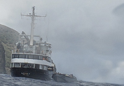
For the Pitcairn Islands mission, a Wave Glider for Maritime Domain Awareness was outfitted with key sensors—an AIS receiver, acoustic sensors, and camera—enabling it to detect surface vessels (even “dark” targets) operating in the surveillance area. The high-definition camera (1080p) captured images of vessel targets and sent thumbnails via Iridium back to a command center (full, high-resolution images were offloaded from the vehicle upon mission completion). On-board meteorological and wave sensors measured wind, pressure, temperature, and sea-surface conditions throughout the mission to give the team real-time insights into environmental and operating conditions.

Vessel captured by Wave Glider camera and sent by Iridium satellite. High-res images available when bandwidth permits.
The Results
The Wave Glider platform can potentially save customers millions by reducing or eliminating the need for ship-based surveillance and ocean monitoring. Customers can leverage real-time contact reports and historic vessel traffic data to focus high-cost assets, such as ships, planes, and other resources, on interdiction. The 4-month mission was executed within a budget of $214,581, which is a fraction of the cost of operating a manned vessel ($5.8M per year). This provided the FCO significant cost savings, along with valuable information on environmental and sea-surface conditions.
The Wave Glider traveled more than 10,000 kilometers during the 4-month mission, covering over 131,000 square nautical miles with acoustics and 247,000 square nautical miles with AIS. Throughout the mission, it provided the onshore team with both historical and real-time feeds of data, including AIS contacts, acoustic contact reports, weather reports, and wave reports. The Wave Glider successfully intercepted and collected data on three targets—vessels that were not picked up by the Wave Glider’s AIS receiver.